Author Topic: Great Circle Mapper Tips and Tricks Master Thread  (Read 10860 times)

Offline Something Fishy

  • Global Moderator
  • Dansdeals Lifetime Presidential Platinum Elite
  • **********
  • Join Date: Jan 2011
  • Posts: 8861
  • Total likes: 6265
  • DansDeals.com Hat Tips 44
    • View Profile
    • Kosher Horizons
  • Location: Iceland
Great Circle Mapper Tips and Tricks Master Thread
« on: September 18, 2016, 03:20:24 AM »
We all know and love GCMap, but based on some recent PMs even some seasoned DDF'ers are not overly familiar with the tool and how it works. I figured I'll put together a list of tips and tricks, as well as some advanced things that I've learned over the years that aren't documented anywhere (including GCMap's own knowledge base).

This thread could also serve as a place to ask any questions about the GCMapper and the like.


- To show the maps here on DDF, right-click on the map and choose Copy image address (Or whatever your browser's equivalent is). Paste the resulting link in to your post as an image.

Update early 2021: This does not currently work due to an HTTPS issue. For now, click the image and save it, then upload to an image host and paste the link as an image.


- The top search bar is useful for basic routes or searches. Start there, then use the field under Map Controls > Paths on the bottom of the page to do advanced things.


- To change the color of a route, put color:yellow, before your route. It doesn't have to be yellow, obviously; you could substitute that with a different color if you want. The color will remain the same for subsequent routes unless a different color is specified.

Code: [Select]
color:yellow,jfk-lax-sin-syd, color:blue, ewr-ord-lax-syd
\


- To see different routes originating from one airport, you don't have to put in all the complete routes (i.e. jfk-lax,jfk-sfo, etc.). Instead, you could just put the origin and separate the destinations with a slash.

Code: [Select]
jfk-lax/sfo/san/sea/pdx


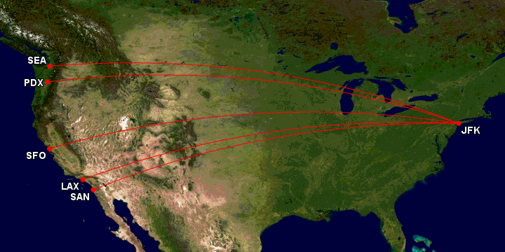
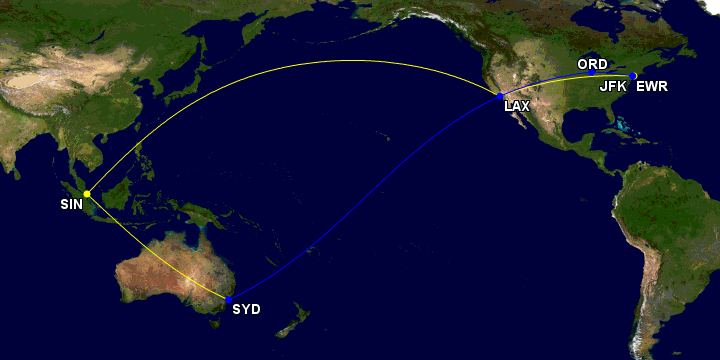
- If your map looks weird, try changing your projection from the default to Rectangular (Plate Carrée). This option is found under Map Controls > Map Conf > Projection.

The first map here automatically gave me a polar projection, which is fine in some cases but doesn't really give you a good sense of place. Manually choosing Rectangular gave me the second map:


- GCMap only gives the option to zoom out of a map, not in. To get around this and only show a portion of your map, use o:noext, before the route that you want to cut off.

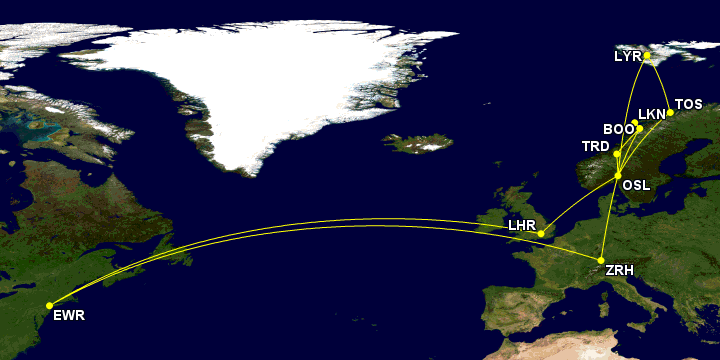
For example, a regular map doesn't show the European flights of this trip as well as I'd like, since it's a very small part of the full map.

Code: [Select]
Color:yellow, Cle-ewr-osl,osl-tos-lyr-osl-trd-boo-lkn-boo-osl-cdg-ewr-cle, ewr-osl-tos-lyr-osl-trd-boo-lkn-boo-osl-cdg-ewr, ewr-lhr-osl-tos-lyr-osl-trd-boo-lkn-boo-osl-zrh-ewr, lhr-osl-tos-lyr-osl-trd-boo-lkn-boo-osl-lhr, tlv-muc-osl-tos-lyr-osl-trd-boo-lkn-boo-osl-bru-tlv
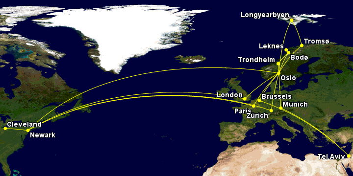

Adding o:noext, before the segments I don't want to show fully gives me exactly what I wanted:

Code: [Select]
Color:yellow,o:noext,Cle-ewr-osl, osl-tos-lyr-osl-trd-boo-lkn-boo-osl-cdg,o:noext,cdg-ewr-cle,o:noext,ewr-osl,osl-tos-lyr-osl-trd-boo-lkn-boo-osl-cdg,o:noext,cdg-ewr,o:noext,ewr-lhr,lhr-osl-tos-lyr-osl-trd-boo-lkn-boo-osl-zrh,o:noext,zrh-ewr,lhr-osl-tos-lyr-osl-trd-boo-lkn-boo-osl-lhr,o:noext,tlv-muc,muc-osl-tos-lyr-osl-trd-boo-lkn-boo-osl-bru,o:noext,bru-tlv,o:noext,binp


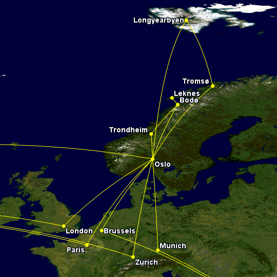
Of course, I could just drop the long hauls from the map, but that would give me no context; it just looks like a flying spree out of Oslo, like so:

Code: [Select]
Color:yellow, osl-tos-lyr-osl-trd-boo-lkn-boo-osl-cdg, osl-tos-lyr-osl-trd-boo-lkn-boo-osl-cdg, lhr-osl-tos-lyr-osl-trd-boo-lkn-boo-osl-zrh, lhr-osl-tos-lyr-osl-trd-boo-lkn-boo-osl-lhr, muc-osl-tos-lyr-osl-trd-boo-lkn-boo-osl-bru


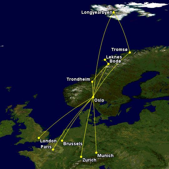
- Entering an airport code instead of a route gives you a point on the map. This could be very useful when planning a trip to an out of the way place.

For example, planning a trip to Greenland drove me crazy. For starters, the airport codes are incredibly unintuative, having nothing to do with the actual airport name. That was compounded by the fact that these names aren't pronounceable in the first place ;D. Add to that the fact that the service to these airports vary wildly, and I needed a better way to start planning this.

Enter GCMap. I used points for each airport, color coded by service, and viola. In this map I used green for the main airport with international service, yellow for smaller international airports with service from Iceland only, and red for airports with domestic Greenland service only. Choosing disc + user entered code + city name from the Map Controls > Markers > Simple dropdown is what enabled both the airport code and city name to be displayed on the map.

Code: [Select]
color:red,jeg,jsu,jfr,thu,naq,jqa,jhs,juv,color:yellow,jav,cnp,kus,uak,goh,color:green,sfj


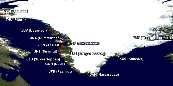
- You could add your own places and names.

To add a place, enter the coordinates. The easiest way to get those is to click on the spot in Google Maps, and the coordinates will show up on the bottom. Click on those, and you could copy and past it into GCMap. It's important to remember that Google and GCMap use coordinates differently; in particular, Google uses negative numbers for S and W, while in GCMap you need to use positive numbers and a  NSEW designation. For example, if Google gives you -74.050755, -41.945649, remove both minus signs, the comma, and space, and specify the direction NS of the Equator and EW of the Prime Meridian, like so: 74.050755s41.945649w.

To add your own place name, enter "%T\xxx"+@ with your text replacing the xxx. Place this before your coordinates, then choose disc + user entered code from the Map Controls > Markers > Simple dropdown.

Code: [Select]
color:white,"%T\Very Cold and Wet Place, But Penguins"+@74.050755s41.945649w
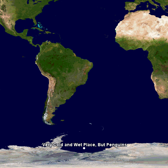


- Entering BINP gives you the North Pole. I'm not sure how or why, but it works ;D.

Code: [Select]
color:yellow,binp


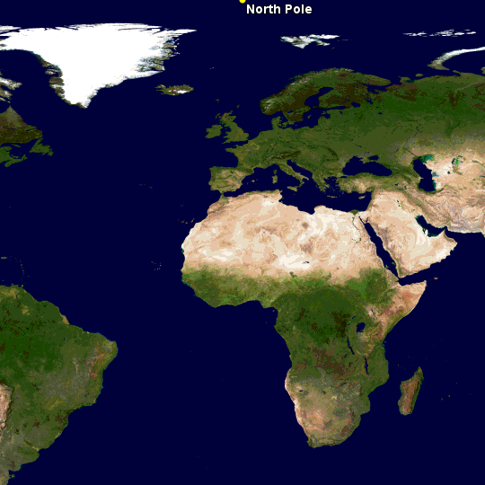
I'm sure there are more, this is just what I could think of at the moment. Feel free to add your own tips.
« Last Edit: January 31, 2021, 09:10:15 PM by Something Fishy »
Check out my site for epic kosher adventures: Kosher Horizons

Offline Yaalili

  • Dansdeals Lifetime 10K Presidential Platinum Elite
  • *******
  • Join Date: Jul 2009
  • Posts: 12809
  • Total likes: 478
  • DansDeals.com Hat Tips 157
  • Gender: Male
    • View Profile
  • Location: Crown Heights, NY
Re: Great Circle Mapper Tips and Tricks Master Thread
« Reply #1 on: September 18, 2016, 07:40:05 AM »
Awesome idea for a thread, bookmarked. Thanks for taking the time.

Offline 3yummyboys

  • Dansdeals Lifetime Platinum Elite
  • *******
  • Join Date: Apr 2013
  • Posts: 1737
  • Total likes: 32
  • DansDeals.com Hat Tips 0
    • View Profile
Re: Great Circle Mapper Tips and Tricks Master Thread
« Reply #2 on: September 18, 2016, 07:56:50 AM »
Thanks!

Offline Hatikvah

  • Dansdeals Gold Elite
  • ***
  • Join Date: Nov 2014
  • Posts: 138
  • Total likes: 2
  • DansDeals.com Hat Tips 2
    • View Profile
  • Location: Brooklyn, NY
Re: Great Circle Mapper Tips and Tricks Master Thread
« Reply #3 on: September 18, 2016, 12:26:40 PM »
Very cool and helpful thanks!

Offline 3yummyboys

  • Dansdeals Lifetime Platinum Elite
  • *******
  • Join Date: Apr 2013
  • Posts: 1737
  • Total likes: 32
  • DansDeals.com Hat Tips 0
    • View Profile
Re: Great Circle Mapper Tips and Tricks Master Thread
« Reply #4 on: September 20, 2016, 02:05:51 PM »
How can I save the image as a regular photo (to put in shutterfly album)?

Offline Something Fishy

  • Global Moderator
  • Dansdeals Lifetime Presidential Platinum Elite
  • **********
  • Join Date: Jan 2011
  • Posts: 8861
  • Total likes: 6265
  • DansDeals.com Hat Tips 44
    • View Profile
    • Kosher Horizons
  • Location: Iceland
Re: Great Circle Mapper Tips and Tricks Master Thread
« Reply #5 on: September 20, 2016, 02:29:22 PM »
How can I save the image as a regular photo (to put in shutterfly album)?

Right click on the map and click save image as.
Check out my site for epic kosher adventures: Kosher Horizons

Offline 3yummyboys

  • Dansdeals Lifetime Platinum Elite
  • *******
  • Join Date: Apr 2013
  • Posts: 1737
  • Total likes: 32
  • DansDeals.com Hat Tips 0
    • View Profile
Re: Great Circle Mapper Tips and Tricks Master Thread
« Reply #6 on: September 20, 2016, 07:56:59 PM »
Right click on the map and click save image as.

It wasn't giving me that option. I ended up right clicking and choosing copy image, pasting it in word and then saving as JPEG. Not the most direct way, but it worked.

Offline chff

  • Dansdeals Lifetime Presidential Platinum Elite
  • *********
  • Join Date: Jul 2012
  • Posts: 5940
  • Total likes: 695
  • DansDeals.com Hat Tips 25
    • View Profile
  • Location: NYC (not anymore)
  • Programs: All of them...
Re: Great Circle Mapper Tips and Tricks Master Thread
« Reply #7 on: September 21, 2016, 02:04:39 AM »
It wasn't giving me that option. I ended up right clicking and choosing copy image, pasting it in word and then saving as JPEG. Not the most direct way, but it worked.
Try pasting into Paint rather then word

Offline Yaalili

  • Dansdeals Lifetime 10K Presidential Platinum Elite
  • *******
  • Join Date: Jul 2009
  • Posts: 12809
  • Total likes: 478
  • DansDeals.com Hat Tips 157
  • Gender: Male
    • View Profile
  • Location: Crown Heights, NY
Re: Great Circle Mapper Tips and Tricks Master Thread
« Reply #8 on: November 16, 2016, 09:48:37 AM »
You can specify a range using the “@” symbol. The default unit is nautical miles (nm) unless some other unit is specified. Options include nautical miles (nm), statute miles (mi), kilometers (km), or minutes (min) at 389 knots. For example 500mi,5000mi@JFK, would be a small circle for 500 miles and a larger one for 5000 miles from JFK.

Offline davidrotts63

  • Dansdeals Lifetime Presidential Platinum Elite
  • *********
  • Join Date: May 2017
  • Posts: 7250
  • Total likes: 979
  • DansDeals.com Hat Tips 26
  • Gender: Male
    • View Profile
  • Programs: Hertz Gold, Hyatt Member, BA Blue, Ebay banned, Amazon Prime
Re: Great Circle Mapper Tips and Tricks Master Thread
« Reply #9 on: December 26, 2018, 05:03:42 PM »


I found out when I quoted @YesThatsMe and modified the codes

http://www.gcmap.com/map?P=EWR-DTW,+DTW-EWR&MS=bm&MR=20&MX=920x360&PM=*

P=     points of travel syntax from-to,+from-to
MX = width by height

Care to elaborate?
(Quit) pulling out the flowers, and watering the weeds. -Peter Lynch

Offline yesitsme

  • Dansdeals Lifetime Presidential Platinum Elite
  • *********
  • Join Date: Dec 2014
  • Posts: 5116
  • Total likes: 2238
  • DansDeals.com Hat Tips 4
  • Gender: Male
    • View Profile
Re: Great Circle Mapper Tips and Tricks Master Thread
« Reply #10 on: December 26, 2018, 05:20:17 PM »

Care to elaborate?
click in and play around see what happens

MR = zoom level
["-"]

Offline myi

  • Dansdeals Lifetime 20K Presidential Platinum Elite
  • ********
  • Join Date: Feb 2015
  • Posts: 23616
  • Total likes: 2441
  • DansDeals.com Hat Tips 356
  • Gender: Male
    • View Profile
  • Location: InMyPants! 🙈
  • Programs: 2Many2List!
Re: Great Circle Mapper Tips and Tricks Master Thread
« Reply #11 on: January 06, 2020, 09:54:10 PM »
SF nice thread well done!
And nice explanation throughout!
Quote
Need your LG Exalt fixed? Cracked in half? Water damage? Or parts to repair yourself. 347.201.2501

Offline Something Fishy

  • Global Moderator
  • Dansdeals Lifetime Presidential Platinum Elite
  • **********
  • Join Date: Jan 2011
  • Posts: 8861
  • Total likes: 6265
  • DansDeals.com Hat Tips 44
    • View Profile
    • Kosher Horizons
  • Location: Iceland
Re: Great Circle Mapper Tips and Tricks Master Thread
« Reply #12 on: January 06, 2020, 09:56:26 PM »
SF nice thread well done!
And nice explanation throughout!

Thanks
Check out my site for epic kosher adventures: Kosher Horizons

Offline israshot

  • Dansdeals Lifetime Platinum Elite
  • *******
  • Join Date: Nov 2018
  • Posts: 1103
  • Total likes: 226
  • DansDeals.com Hat Tips 14
    • View Profile
  • Location: NYC
Re: Great Circle Mapper Tips and Tricks Master Thread
« Reply #13 on: April 21, 2020, 08:48:56 AM »
Why to use the circle mapper and not a simple tool like my.flightradar24 ?
Is it to put an emphasis on the #AvGeek persona?

Offline Something Fishy

  • Global Moderator
  • Dansdeals Lifetime Presidential Platinum Elite
  • **********
  • Join Date: Jan 2011
  • Posts: 8861
  • Total likes: 6265
  • DansDeals.com Hat Tips 44
    • View Profile
    • Kosher Horizons
  • Location: Iceland
Re: Great Circle Mapper Tips and Tricks Master Thread
« Reply #14 on: April 21, 2020, 10:50:14 AM »
Why to use the circle mapper and not a simple tool like my.flightradar24 ?
Is it to put an emphasis on the #AvGeek persona?

Um, because Flightradar has none of the GCMap features?
Check out my site for epic kosher adventures: Kosher Horizons

Offline Kobe Bryant

  • Dansdeals Presidential Platinum Elite
  • ********
  • Join Date: Jan 2017
  • Posts: 3980
  • Total likes: 2288
  • DansDeals.com Hat Tips 17
    • View Profile
Re: Great Circle Mapper Tips and Tricks Master Thread
« Reply #15 on: December 30, 2020, 09:42:16 AM »
Another great SF special. A concise and well written piece.

Offline Dan

  • Administrator
  • Dansdeals Lifetime 50K Diamond Elite
  • **********
  • Join Date: May 2008
  • Posts: 68893
  • Total likes: 17267
  • DansDeals.com Hat Tips 16442
  • Gender: Male
    • View Profile
  • Location: CLE
  • Programs: UA GS, AA EXP, DL Dirt, Hyatt Glob, Fairmont Lifetime Plat, DD Diamond, Blocked By @NeriaKraus
Save your time, I don't answer PM. Post it in the forum and a dedicated DDF'er will get back to you as soon as possible.